Trips Places Foods Stories Newsletters
Loading...
Loading...
Loading...
Loading...

No search results found for
“”

Make sure words are spelled correctly.

Try searching for a travel destination.

Places near me Random place

Popular Destinations

  • Paris
  • London
  • New York
  • Berlin
  • Rome
  • Los Angeles
Trips Places Foods Stories Newsletters
Sign In Join
Places near me Random place
All the United States New York State New York City Neversink Neversink

Neversink

The lost town of Neversink, sunk by New York City.

Neversink, New York

Added By
Luke Spencer
Email
Been Here
Want to go
Added to list
CAPTION
Dam along Route 55   City Data
Main street running through Neversink   Between the Lakes
The town of Neversink in the 1920s   Between the Lakes
Neversink reservoir and dam, along Route 55   Daniel Case on Wiki
Been Here
Want to go
Added to list

About

The residents of New York City consume over 1,000 million gallons of water a day, roughly about 125 gallons per person.

Over half of the city's water supply is fed from the Catskills Mountains, and one of its biggest man made reservoirs, the Neversink.

Located 75 miles northwest of the city along Route 55 in Sullivan County, the Neversink reservoir has been providing fresh running water for Manhattanites since 1953, many of whom give little thought as to where their water comes from. But 175 feet below the surface of the reservoir lies a lost town with perhaps the most bittersweet name of any town in American history.....the flooded town of Old Neversink.

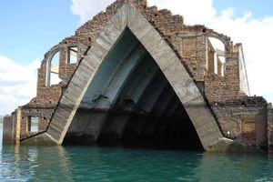
Founded in 1798 and with a population of over 2,000 souls by the time of its destruction, it was one of the many quintessential small towns that give the Catskills its character. Town life centered around the main street, covered bridge, two-roomed district school and a Methodist chapel.

All that changed in 1941 when the Board of Water Supply decided that the growing population of New York City needed more water, and nothing would stand in their way to get it. Construction on the reservoir began, and a dam was built under what is now Route 55. On June 4th, 1953 the Neversink River flooded the valley, taking the small town of Neversink with it.

The town's protests fell on deaf ears as the floods took their centuries old homes, cemeteries, businesses and farms. So the next time you pour a glass of water in New York City, perhaps you will spare a thought for what it cost the inhabitants of the flooded and forgotten lost town of Neversink. 


Related Tags

Disaster Areas Dams

Community Contributors

Added By

Luke J Spencer

Edited By

Rachel, georgannasilvia

  • Rachel
  • georgannasilvia

Published

June 17, 2013

Edit this listing

Make an Edit
Add Photos
Neversink
Route 55
Sullivan County
Neversink, New York, 12765
United States
41.849502, -74.61357
Get Directions

Nearby Places

Parksville

Parksville, New York

miles away

Nevele Grand

Ellenville, New York

miles away

Craig-E-Clair Castle

Roscoe, New York

miles away

Explore the Destination Guide

Photo of New York State

New York State

United States

Places 807
Stories 45

Nearby Places

Parksville

Parksville, New York

miles away

Nevele Grand

Ellenville, New York

miles away

Craig-E-Clair Castle

Roscoe, New York

miles away

Explore the Destination Guide

Photo of New York State

New York State

United States

Places 807
Stories 45

Related Stories and Lists

Drowned Towns Lost to Progress

ruins

By Chris White

Related Places

  • Carmen Tower.

    Tlalpujahua, Mexico

    Carmen Tower

    This lonely tower survived the landslide that devastated much of a Mexican mining town.

  • Fergus Falls, Minnesota

    Broken Down Dam Park

    A riverside park built around the ruins of a massive dam that collapsed in 1909.

  •  The breach in the dam wall.

    Dolgarrog, Wales

    Remains of the Dolgarrog Dam Disaster

    The worst flood disaster in Welsh history might have been a lot worse if it had not happened on movie night.

  • The view of the dam and the valley behind.

    Vilminore di Scalve, Italy

    Gleno Dam

    The sinister ruins of one of the worst dam failures of the 20th century lie in this astonishing alpine setting.

  • Castlewood Canyon Dam Ruins

    Castle Rock, Colorado

    Castlewood Canyon Dam Ruins

    The remains of the dam that unleashed a 15-foot wall of water on Denver.

  • A view of Lake San Cristobal

    Hinsdale County, Colorado

    Lake San Cristobal

    Colorado’s second largest natural lake was created by a landslide.

  • Sunset over the reach, with wasteway in foreground.

    Helen, Washington

    Hanford Reach National Monument

    The only undammed section of the Columbia River in the United States has been preserved, ironically, by its proximity to the Hanford Nuclear Reservation.

  • Bonneville Dam

    North Bonneville, Washington

    Bonneville Lock & Dam

    Boats and fish both find their way through this massive hydroelectric structure.

Aerial image of Vietnam, displaying the picturesque rice terraces, characterized by their layered, verdant fields.
Atlas Obscura Membership

Become an Atlas Obscura Member


Join our community of curious explorers.

Become a Member

Get Our Email Newsletter

Follow Us

Facebook YouTube TikTok Instagram Pinterest RSS Feed

Get the app

Download the App
Download on the Apple App Store Get it on Google Play
  • All Places
  • Latest Places
  • Most Popular
  • Places to Eat
  • Random
  • Nearby
  • Add a Place
  • Stories
  • Food & Drink
  • Itineraries
  • Lists
  • Video
  • Podcast
  • Newsletters
  • All Trips
  • Family Trip
  • Food & Drink
  • History & Culture
  • Wildlife & Nature
  • FAQ
  • Membership
  • Feedback & Ideas
  • Community Guidelines
  • Product Blog
  • Unique Gifts
  • Work With Us
  • About
  • FAQ
  • Advertise With Us
  • Advertising Guidelines
  • Privacy Policy
  • Cookie Policy
  • Terms of Use
Atlas Obscura

© 2025 Atlas Obscura. All Rights Reserved.